Closing in
0
...
Menu
Search
LATEST
POPULAR
AIRCRAFT FOR SALE
SECTIONS
Business Aviation
Defense
Aerospace & Air Transport
FutureFlight
Rotorcraft
General Aviation
SUSTAINABILITY & ENVIRONMENT
CHANNELS
Aircraft
Maintenance
Avionics
Charter & Fractional
Safety
All Categories
News Archive
Newsletter Archive
MORE
AIN FBO Survey
Airshows & Conventions
Aviation Events
Compliance Countdown
Expert Opinion
In-Depth Reports
Leeham News & Analysis
Print Archives
Videos
Webinars
Whitepapers
ABOUT
About AIN
Our Writers
History
Advertise
Contact Us
Subscribe
LATEST
POPULAR
AIRCRAFT FOR SALE
SECTIONS
ABOUT
Search
Subscribe
Search
Safety
WSI Reboots Pilotbrief with zippy features
On May 3, Weather Services International announced the launch of a new version of its online Pilotbrief weather information service, Pilotbrief Optima.
Share
Post
Share
Print
Copy
Email
By
Matt Thurber
• Editor-in-Chief
May 29, 2011
More In Safety
Hughes App Highlights Slacklines in Route Planning
Free service helps pilots evaluate risk before flight
Safety
Wisk, Boeing Sued over eVTOL Software Safety Claims
Fired software manager alleges retaliation, discrimination
Safety
Helping Families through Emergencies
Fireside Partners’ Gina Shealy advises on the difficult task of family notification
Safety
Bombardier Opens Registration for Flight Attendant Safety Summit
Aviation Secure’s Kristopher Cannon returns as a presenter
Safety
FAA Investigates Bizjet Runway Incursion at Miami Int’l
An American Airlines A319 rejected takeoff when a Phenom 300 crossed the runway
Safety
AINsight: Threat-forward Briefings Are Smart and Safe
Skip the formulaic approach/departure briefings for ones that highlight specific threats and create open dialogue
Safety
ALPA’s Ambrosi Tells Senate Close Call Fixes Can’t Wait
Testimony cites January 2025 and March 2026 fatal accidents
Safety
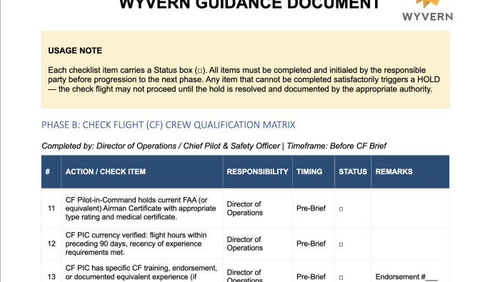
New Wyvern Guidance Addresses Return-to-service Risks
Guidance includes sample post-maintenance checklists
Safety