Closing in
0
...
Menu
Search
LATEST
POPULAR
AIRCRAFT FOR SALE
SECTIONS
Business Aviation
Aerospace & Defense
Rotorcraft
General Aviation
FutureFlight
SUSTAINABILITY & ENVIRONMENT
CHANNELS
Aircraft
Maintenance
Avionics
Charter & Fractional
Safety
All Categories
News Archive
Newsletter Archive
MORE
AIN FBO Survey
Airshows & Conventions
Aviation Events
Compliance Countdown
Expert Opinion
In-Depth Reports
Leeham News & Analysis
Print Archives
Videos
Webinars
Whitepapers
ABOUT
About AIN
Our Writers
History
Advertise
Contact Us
Subscribe
LATEST
POPULAR
AIRCRAFT FOR SALE
SECTIONS
ABOUT
Search
Subscribe
Search
Avionics
Jeppesen Begins Mapping Taxiways at Airports around the World
Jeppesen has undertaken an ambitious yearlong effort to survey taxiways and ramp areas at high-use airports throughout the world.
Share
Post
Share
Print
Copy
Email
By
Stephen Pope
February 1, 2007
More In Avionics
Garmin Expands Navigation Database To Include Africa
Adds 40 countries in Africa with airspace info, IFR procedures, frequencies, etc.
Avionics
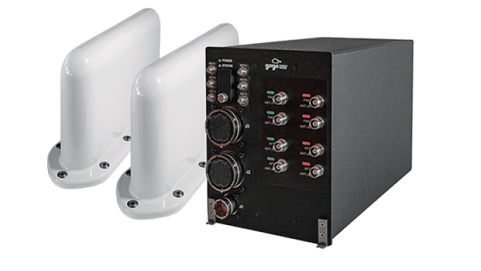
Pro Star Earns STC for Gogo Galileo on Pilatus PC-12
System can maintain connectivity over open water, in remote areas, and in polar regions
Avionics
GFD Picks Universal Avionics for Learjet 35A/36A Upgrade
Modification replaces original instrumentation with glass cockpit displays
Avionics
Merlin’s Autonomous C-130J Passes Critical Design Review
USSOCOM program advances into aircraft integration phase
Avionics
Dynon Adapts Light Sport Avionics for Air eVTOLs
Air One eVTOL will feature customized SkyView HDX avionics
Avionics
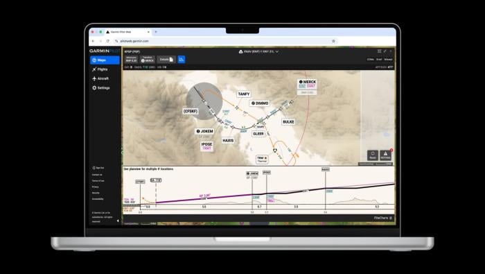
Garmin SmartCharts Now Available on Pilot Web
Procedures simplify view by decluttering unnecessary information
Avionics
Pentastar Gets STC for Gogo LX5 Installs on Gulfstreams
STC covers installation of LX5 on GIV/G450/GV/G550 models
Avionics
Tamarack Aerospace Announces AirConnect IFC for Citations
System includes aircraft-grade cabin Wi-Fi distribution, certified electrical integration
Avionics